
Update on Cycle Superhighway 1
In 2015 Transport for London (TfL) and Hackney Council announced improvements to CS1 in Hackney. Following further consultations, additional improvements around De Beauvoir Road and Wordsworth Road were installed to reduce rat-running traffic.
Following a review of these schemes, and taking into account feedback from residents, a number of actions are being planned to reduce traffic and improve the CS1 route in Hackney.
The route has been divided into five sections, with the main actions listed below. All proposals will be subject to relevant consultation and approval processes.
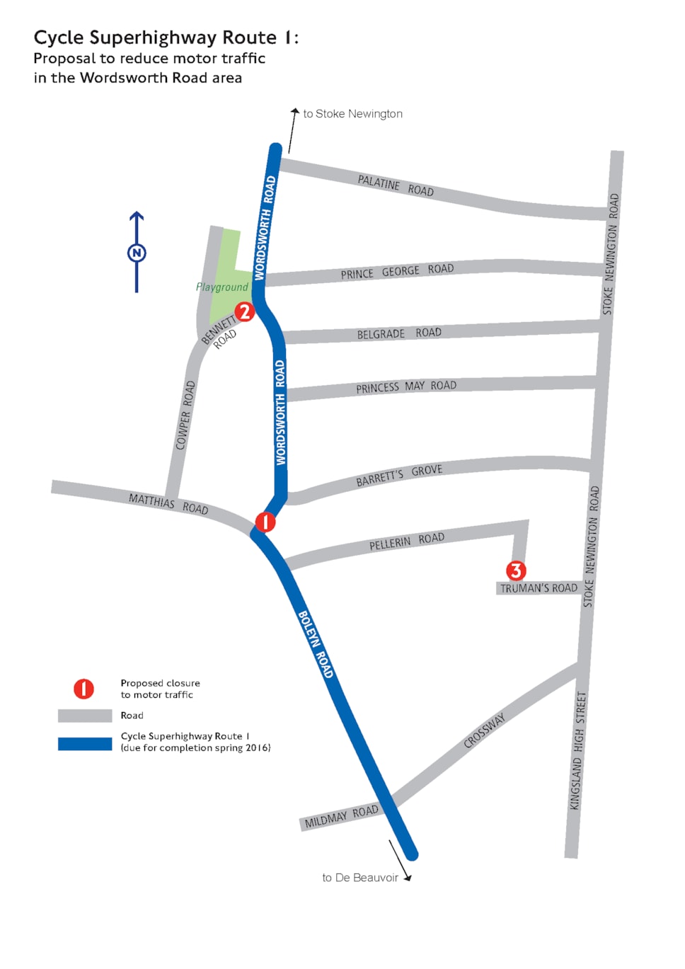
Last year, as part of Cycle Superhighway Route 1 (CS1), three roads were filtered to restrict through traffic around Wordsworth Road. These measures have succeeded in reducing motor traffic on the cycle route and improving road safety near schools.
In December 2017 and January 2018, we consulted on traffic-calming measures in the area bounded by the A10 Kingsland Road, the B104 Stoke Newington Church Street and Albion Road, and Mildmay Road / Crossway, aimed at reducing the volume of traffic travelling through the area and improving safety for cyclists along Cycle Superhighway 1 (CS1), while still allowing residents to access their homes.
The proposals followed concerns from residents and businesses that increased numbers of vehicles are rat-running along residential roads, including Walford Road, Brighton Road and Nevill Road. They are aimed at making the area safer and more pleasant for everyone, especially pedestrians and cyclists, and creating healthy, safe and attractive streets for people to enjoy.
During the consultation, some residents became concerned about the effect that the proposals could have on air quality on Stoke Newington Church Street and outside William Patten School. As a result, we postponed a decision on the proposals and commissioned more detailed traffic and air quality research from independent consultants to find out what the proposals would mean for the Stoke Newington area.
We expected to share this modelling with residents in October, but, unfortunately, the modelling process is taking longer than anticipated. We apologise for this delay.
The detailed traffic and air quality modelling will:
-
assess the degree to which nitrogen dioxide concentrations would increase or decrease and identify areas that would experience significant increases or decreases
-
highlight areas where the changes would likely result in a new breach of the National Air Quality Objectives (NAQO) or where an existing breach of NAQO would be significantly exacerbated
-
identify whether the overall area exceeding the NAQO would shrink or increase.
Any potential impacts on traffic and air quality will be published when completed, alongside a full analysis of the consultation responses, including petitions.
Hackney Council has been working with William Patten School as part of our schools air quality monitoring project for some time. We are working with the school to put in place measures to reduce pupil exposure to air pollution, which includes paying for a green wall and screens for the school gates.
What happens next
-
We expect to receive the detailed air quality modelling back from the independent consultants at the end of the year.
-
We will consider the findings of the air quality modelling, and expect to make a decision on the Walford Road improvements early in the New Year, working with Transport for London to take into account the potential impacts of the Stoke Newington Gyratory proposals. We will only make a decision on the scheme when its impact on the area is fully understood.
-
Information relating to the decision, including the results from the consultation and the air quality modelling, will be published on the Council’s website and sent to residents in Stoke Newington.
The filters in the Wordsworth Road area will be retained. These have proved controversial due to increased traffic on Brighton Road and Walford Road in particular, and the fact that residents’ ability to drive across the area is restricted. However, the Council feels that the closures have succeeded in reducing traffic on the cycle route and improving air quality and road safety near the schools.
The existing closures, implemented in temporary materials, will be upgraded with measures such as physical kerb build outs
Build outs will be implemented at the school crossing patrol location by St Matthias School.
A design workshop will be held with local residents to develop ideas to reduce the conflicts between pedestrians and cyclists around Butterfield Green.
- Signed decision paper
- Appendices
A protected cycle lane will be built on West Bank following consultation earlier this year. The outcome of the consultation shows overall support for the scheme.
Investigating options to improve safety around Dunsmure Parade.
Protected crossing to be built at Manor Road / Bouverie Road / Heathland Road, subject to be built at Manor Road / Bouverie Road / Heathland Road, subject to resolving technical issues.
Junction to be made permanent and safer by building a wider island, narrower junction mouth and raised entry to help enforce the one-way operation. Additional signage to be added and guard rail to be removed to improve crossing point.
Design for a parallel pedestrian & cycle crossing has been prepared and is being consulted on during November.
- Signed decision paper
- Appendices
This area is still difficult for cyclists due to parking and loading arrangements. These are being reviewed with Islington Council and will be rationalised where possible.
Further closures under investigation to reduce traffic crossing Pitfield Street.
Zebra crossing to be raised to slow traffic.
Investigating a scheme to reduce traffic and simplify the junction.
This section is jointly maintained by Hackney and Islington and is also on the Strategic Road Network. Discussions are still ongoing but the aspiration remains for a protected cycle lane on Balls Pond Road between its junctions with Culford Road and Kingsbury Road.